
Kandersteg · Oeschinensee
Oeschinensee Hike: Which Route to Take
Last updated November 2026
Most people take the gondola and walk the direct path (trail C) to the lake. For the famous view from above, add the panorama route via Läger and Heuberg (trail G) and come down to the shore. Without the gondola, trail A climbs from the valley station in about 90 minutes. Check the official trail status first.
Some booking links may earn us a commission at no extra cost to you. How this guide is funded →
Once you’re at the top station, the path you pick changes the day: a gentle shore walk, a panorama trail, or a full climb from the valley without the gondola.
The operator labels routes with letters (A–K). Below is a plain-English comparison of the main ones — times, who they suit, and what to check in winter. Book a gondola slot in summer before you lock a long hike, and see getting there if you’re still arriving from the station.
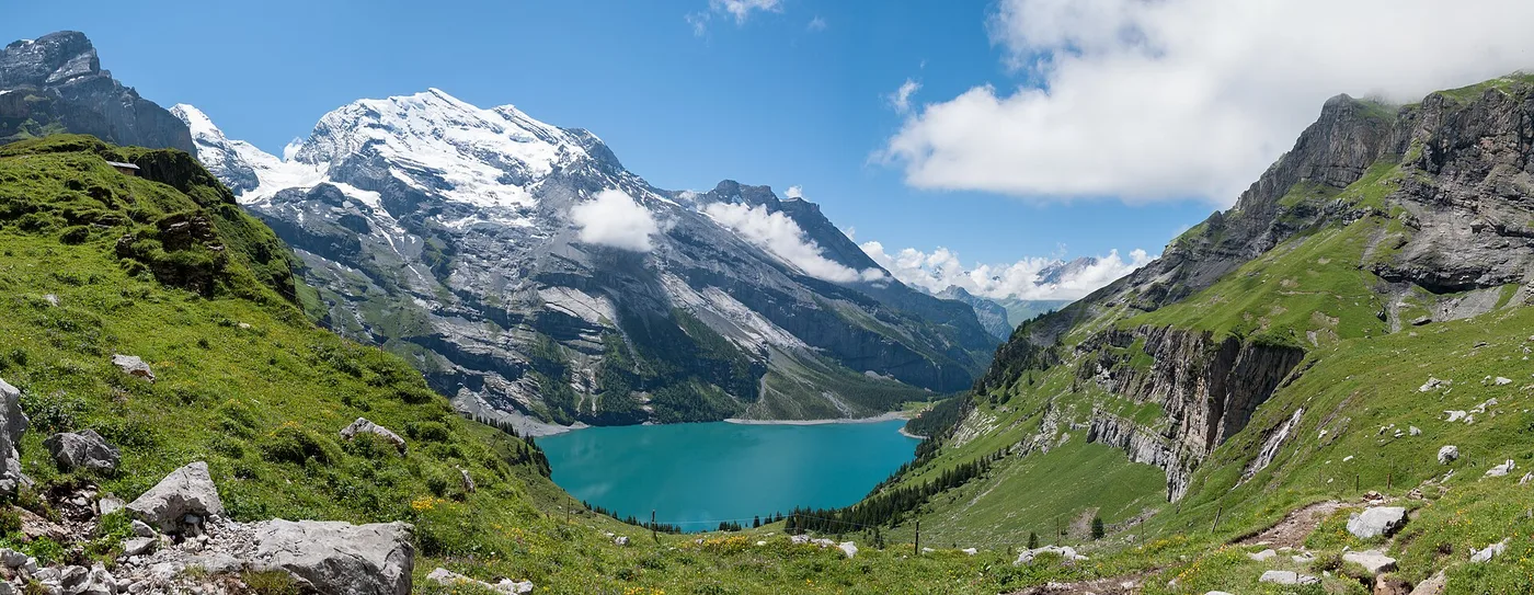
Oeschinensee panorama toward the Doldenhorn — trail country above Kandersteg.
Which route?
Times and trail types below follow the English list on oeschinensee.ch. We give walking times, not a single loop distance — third-party apps often disagree, so trust the official map.
| Letter | From → to | Time | Type | Who it suits | Winter note |
|---|---|---|---|---|---|
| C | Mountain station → lake (direct) | About 20–30′ | Wide path (gravel / partly asphalt) | Most visitors; baby carriages when marked suitable | Check winter path status |
| D | Mountain station → lake via Läger | About 40′ | Panorama path | View seekers, moderate walkers | Confirm seasonal access |
| A | Lower station → lake | About 90′ | Climb from the valley | Fit walkers skipping the gondola up | Often snowy; judge conditions |
| K | Along the lakeshore | About 10′ | Shore path | Short lakeside stretch | Ice / snow rules apply |
| E | Lake → Underbärgli | About 40′ | Mountain trail | Hikers continuing above the shore | Mountain gear mindset |
| G | Läger–Heuberg–Oberbärgli | About 1 h 30 | Mountain trail | Panorama / Heuberg loop hikers | Icy in early winter; winter gear needed |
| H | Oberbärgli → Hohtürli | About 3 h | Mountain trail | Strong hikers toward the hut | High alpine; seasonal |
| I | Underbärgli → Fründenhütte | — | Alpine trail | Experienced parties | Opens around June |
| J | Kandersteg → Doldenhornhütte via Waldhotel | About 2 h 20 | Challenging | Strong hikers | Not a casual lake stroll |
| F | Lower station → Wetterbach | About 2 h | Mountain | Prepared hikers with mountain gear | Confirm status |
| B | Huble | — | — | — | Closed — construction zone (at time of checking) |
Open the official interactive map on oeschinensee.ch before you leave — we do not embed third-party maps here.
The direct path (C)
Trail C from the mountain station to Oeschinensee is the “Direttissima”: about 20–30 minutes on a wide gravel path that is partly asphalt and described as suitable with baby carriages when conditions match that description. This is the default after the gondola for first visits, families and anyone short on time.
It is still a mountain path: wet gravel, crowds and weather matter. Pair it with gondola timing so you are not racing a last descent. If you only walk C and the shore (K), you have “done the lake”; you have not done the panorama.
The panorama trail (D) and Heuberg loop (G)
Trail D from the mountain station to the lake via Läger takes about 40 minutes: panoramic, with flowering meadows in season and a viewpoint over the water.
What most blogs call the “Oeschinensee panorama hike” usually mixes D toward Läger with mountain trail G (Läger–Heuberg–Oberbärgli, about 1 h 30) and often returns toward the shore via E (Oeschinensee–Underbärgli mountain trail, about 40 minutes). Check that loop combination on the official map — letters can be linked in more than one order, and closures break any blog “clockwork” itinerary.
Heuberg is where the classic elevated lake photos come from. Treat G as a mountain trail: boots, weather buffer and an honest fitness check. Early winter ice on G is called out by the operator; do not improvise summer shoes on glazed rock.
Hiking up without the gondola (A)
Trail A from the lower station to Oeschinensee takes about 90 minutes. This answers “can you hike without the cable car?” — yes. It is a sustained climb, not a flat valley stroll. Many walkers go up on A and down by gondola (or the reverse) when tickets and slots allow; read the gondola rules so your mix of modes is valid.
If you are coming from town without riding up first, still plan getting there from the station to the valley station, then start A with daylight and water to spare.
Longer: Oberbärgli, Hohtürli and Blüemlisalp hut
Beyond the lake bowl, H continues Oberbärgli–Hohtürli in about 3 hours as a mountain trail, and alpine options such as I toward Fründenhütte are seasonal. For the hut overnight or the high traverse context, continue on Blüemlisalp hut and the wider Kandersteg hikes hub. Those days need hut rules, weather windows and honest experience — this page only points the way.
Other marked options on the same list include J (Kandersteg–Doldenhornhütte via Waldhotel, about 2 h 20, challenging) and F (lower station–Wetterbach, about 2 hours, mountain gear). Neither is a substitute for the short lake walk.
Difficulty and what to bring
Path letters (C, D, K) and mountain / alpine letters (E, G, H, I, J, F) are not the same commitment. Bring boots with grip for anything beyond the wide path, layers for wind at the viewpoint, water, and a plan that fits the last gondola if you are riding down. Check weather and conditions the same morning.
We do not give mountaineering instruction, rope advice or “this grade is fine for beginners” guarantees. If a marking says mountain or alpine trail and you are unsure, choose C/D or hire a guide.
Closures and rockfall
Trail B (Huble) was listed as closed for a construction zone at the time of checking. Spitzen Stein instability has closed sectors in recent years (see the lake hub). If a letter you wanted is shut, pick another from the table or another valley day — do not bypass barriers.
Hiking in winter
Winter changes surfaces faster than summer blogs admit. G can be icy in early winter and needs winter gear. Which paths are cleared, snow-covered or closed belongs on Oeschinensee in winter plus the official winter pages. We never make safety claims about ice or winter trails.
Make it a two-day hike
A panorama day plus a second trail or Blausee morning is easier if you sleep in Kandersteg: book hotels at the lake or a village base on where to stay, then walk early before day-trip crowds hit trail C.
Prefer a guide?
Private guided panorama hiking from the Tourist Center in Kandersteg is one way to stop guessing letter combinations:

Photo: GetYourGuide
Village favourite
Kandersteg: Oeschinensee Panorama Hike with a Swiss Athlete
- Private guided panorama hike
- Gondola optional at extra cost
Listing checked November 2026
Still carry the official status link — a guide does not override a closure.
Your questions, answered
How long is the Oeschinensee hike?
It depends on the letter. Trail C from the mountain station is about 20–30 minutes to the shore. The panorama via Läger (D) is about 40 minutes. Hiking up from the valley on A is about 90 minutes. Longer mountain letters add one to three hours. Use official times, not a single blog mileage.
Is the Oeschinensee hike hard?
Trail C is a wide, relatively easy path when open and marked suitable for baby carriages. Mountain trails such as G, H, I, J and F need boots, fitness and mountain awareness. We do not rate routes as “safe” — check conditions and your own experience.
Can you hike to Oeschinensee without the cable car?
Yes. Trail A from the lower station to the lake takes about 90 minutes up. Many people still ride the gondola one way. Confirm gondola rules on the gondola guide if you mix modes.
What is the Oeschinensee panorama trail?
Blogs usually mean the views via Läger and Heuberg — typically trail D toward Läger plus mountain trail G (Läger–Heuberg–Oberbärgli), often finishing toward the shore via Underbärgli (E). Verify the loop on the official interactive map before you go.
Which direction should you hike the loop?
There is no single mandatory direction. Many walkers ride up, take the higher panorama segments, then descend to the shore. Choose based on weather, ice, crowds and which segments are open that day.
Can you do the hike in winter?
Some segments are snow-covered or need winter gear; G is noted as icy in early winter. Cleared or winter-only options change with the season — see the Oeschinensee winter guide and official status.
Is there a map of the trails?
Yes. Use the official interactive map and trail status on oeschinensee.ch — it stays more current than third-party maps.